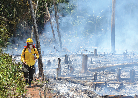
The aftermath of a fire in Bolivia’s northern Chiquitanía region. (Photo courtesy of Fundación Amigos de la Naturaleza)
Pandemic lockdowns during 2020 did not prevent humans in that single year from deforesting more than 9,650 square miles (25,000 square kilometers) of Amazonia—an area larger than El Salvador. That brings total deforestation since 2001 to 209,492 square miles (542,581 square kilometers), an area nearly the size of Guyana, according to a report by a consortium of Latin American nonprofit environmental and indigenous rights groups.
A grim picture, to be sure, but researchers do see a ray of hope. They point to a series of recent studies showing that most deforestation occurs outside of official protected areas and indigenous territories, which remain relatively intact. Policies aimed at conserving those currently unprotected areas could make it possible to preserve enough forest to prevent the Amazon region from reaching a tipping point that could turn much of the Amazon basin into savanna, the scientists say.
But the drivers of deforestation vary from country to country and even within individual countries, ranging from cattle ranching in Brazil and Bolivia to farming in Peru, Ecuador and Colombia to small-scale gold mining in parts of several nations. A variety of policies is needed to address them, experts say.
“There is no single formula for the entire region,” says Alicia Guzmán, the Quito, Ecuador-based coordinator of the nonprofit Stand.earth’s Amazon program. “Protection of Amazonia takes different forms in each country, depending on its reality.”
Whatever the particular causes or combination of causes of land clearing, experts are warning ever more insistently that time is running out. Among them is Brazilian climate scientist Carlos Nobre, who joined the late tropical ecologist Thomas Lovejoy in asserting that the loss of one-quarter of the forest in the eastern, central and southern Amazon will have catastrophic results.
Beyond that, “we are going to exceed the tipping point,” Nobre said on Sept. 20, during a virtual presentation of Amazonia Against the Clock, a report published on Sept. 5 by the Amazon Network of Georeferenced Socio-Environmental Information (Raisg), a consortium of nonprofit environmental and indigenous groups.
That’s when the drying of the rainforest will feed on itself, “[and] there is no way to recover, to go back 30 to 50 years,” Nobre said. “Between 50% and 70% of the Amazon forest will degrade into [an] open canopy ecosystem. It will lose close to 300 billion tons of carbon dioxide into the atmosphere, make it very difficult to reach the Paris Agreement [emission-reduction] targets,” and will lead to the extinction of “hundreds of thousands of species. This is the risk.”
Exactly how close we are to the tipping point depends on what we assume the original forest’s dimensions to be. Matt Finer of the Washington, D.C.-based nonprofit Amazon Conservation, worked backward in time to gauge the size of the Amazon forest before Europeans arrived. He calculates it once covered nearly 2.5 million square miles (6.47 million square kilometers), and that about 13% of that—an area twice the size of Paraguay—has been destroyed so far.
Other estimates are slightly higher, up to 17% or 18%, depending on how the basin’s boundaries are drawn.
Raisg started with a larger area based on both the watershed and on the region’s modern political boundaries. That study analyzed an area of about 3.27 million square miles (8.47 million square kilometers). It estimated that about 26% already has been highly degraded or “transformed” from its original state—either deforested or converted from natural grassland or cerrado into pasture, cropland or another human use.
Southern and southeastern Amazonia, where nearly one-third of the forest has been destroyed, is perilously close to a tipping point, Nobre asserts. There, the dry season is now four to five weeks longer, two to three degrees Celsius warmer and 20% to 30% drier than before 1979, he says, noting that trees accustomed to a wetter climate are undergoing dieback “over a vast area from Bolivia to the Atlantic.”
Adds Nobre: “In portions of that area, the forest has become a carbon source [rather than a carbon sink] due to this hotter and drier climate and increased tree-mortality rates.”
Despite the dire outlook, scientists believe there is still time to stave off the most calamitous scenarios. With roughly three-fourths of the Amazon basin still intact or only slightly degraded—the bulk of it within protected areas and indigenous territories—Raisg has joined Amazonian indigenous organizations and the green group Stand.earth to call for forest restoration. Specifically, they are pushing for protection of existing forest ecosystems and restoration of enough degraded land to protect at least 80% of the Amazon by 2025.
“Amazonia is not isolated, and it is feeling the effects of deforestation, the effects of climate change, the effects of lack of respect for the lives of those who defend the Amazon forests, and that is reflected in an Amazonia that is at the point of no return,” says José Gregorio Díaz Mirabal, general coordinator of the Coordinator of Indigenous Organizations of the Amazon River Basin (Coica).
Accounting for differences
The Raisg report classifies ecosystems as intact, lightly degraded, highly degraded or completely transformed. It also identifies protected areas, indigenous territories, places where those two types of lands overlap, and areas outside of them.
Forest loss was highest outside of protected areas and indigenous territories. Overall, only about 7% of indigenous territories, 9% of protected areas and 3% of overlapping protected and indigenous areas had been transformed or highly degraded. Beyond those areas, though, the basin-wide figure rose to 43%—pointing up the need for a moratorium on extractive activities on these “undesignated” lands, Guzmán says.
In addition, deliberately set agricultural fires that escaped control during the period 2001 to 2020 have affected an area the size of Bolivia, according to the Raisg report. Fires increase woodland degradation as they burn into the understory of intact forest around the edges of cleared fields. This, in turn, accelerates the drying of the surrounding forest.
The Brazilian and Bolivian Amazon regions show the highest amount of ecosystem transformation and degradation—34% and 24%, respectively, according to the Raisg study. The Amazon regions of Ecuador (16%), Colombia (14%) and Peru (10%) register more moderate amounts, while Guyana, French Guiana, Suriname and Venezuela are listed in the single digits.
The greatest loss is in southern Brazil and portions of Bolivia, a so-called arc of deforestation that scientists say has “tipped” and now emits more carbon than it absorbs. (See "Doubts about Amazon’s future as a carbon sink" —EcoAméricas, August 2021.)
The reasons for the deforestation vary. In Peru, wildcat alluvial gold mining has devoured some 40.9 square miles (106 square kilometers), mainly in the southeastern Madre de Dios region. Farther north, immigrant Mennonite farmers have cleared nearly 15 square miles (39 square kilometers) of Peruvian forest since 2017 in the Ucayali and Loreto regions.
They argue that the forest was secondary growth and they purchased it in good faith, but a Peruvian government prosecutor is investigating whether they received permits legally.
Although Peru’s overall deforestation rate is still relatively low, 2020 saw the highest rate since 2000. That’s mainly because of a lack of monitoring and law enforcement during the worst of the Covid-19 pandemic, says Sandra Ríos, Raisg technical coordinator at the Instituto del Bien Común in Lima.
“The source of deforestation in Peru is illegality,” Ríos says, noting that the main drivers of deforestation are illegal mining, drug crops and land trafficking for agriculture, often facilitated by corrupt officials who provide irregular permits. Those activities are encroaching on both indigenous territories and non-indigenous communities, often causing local conflict and in many cases endangering the lives of those opposing the destructive land-use trends.
The loosening of conservation restrictions is also a concern. Ríos notes that an effort is under way in the Peruvian Congress to change the country’s forestry law so farmers can convert their forest to cropland or pasture without seeking permits, as is currently required.
Laws should spur production through more intensive use of existing farmland rather than the clearing of additional acreage, she says. And as land-use monitoring improves thanks to satellite and drone imagery, Ríos would like to see it brought to bear on behalf of farmers and indigenous communities struggling to protect their forests from land speculators, drug traffickers or other outsiders.
In Bolivia, where fires burned nearly 15,444 square miles (40,000 square kilometers) of the Amazon in 2020, policy is part of the problem, says Marlene Quintanilla, a lead author of the Raisg report. (See "Bolivia suffers as ‘chaqueo’ burns escape control " —EcoAméricas, October 2020.)
Like many Latin American countries, Bolivia underwent land reform in the last century in which estates were redistributed to farmers who had labored on them. The saying that “land is for those who work it” remains ingrained in legislation and public attitudes, says Quintanilla, director of research and knowledge management at Friends of Nature Foundation in Santa Cruz, Bolivia.
The result, she says, are misguided requirements that a settler must clear between five and 25 hectares (12 and 61.7 acres) of land in order to obtain title, and that if the property remains forested it is deemed “idle land.”
Migration from Bolivia’s Andean highlands to the Amazonian lowlands has increased in recent years, especially to the Chiquitanía—the northeastern part of Bolivia that, together with adjacent areas of southern Brazil, form an arc of deforestation. Often the settlers are small farmers who clear land for crops, then obtain title; but because the soil is poor and they cannot invest in improvement, they eventually sell the land to ranchers.
Drying of the forest
As agriculture encroaches on protected areas and indigenous territories, fires increasingly damage intact humid forest, Quintanilla says, drying it out and making it more prone to dieback and to burning again in the future.
The drying is also changing the climate. During 2001-20, rainfall levels over the Chiquitanía were 17% lower and average temperatures were 2 degrees Celsius higher than during the previous two decades. And the dry season, meanwhile, grew from three months to five.
Although southern Brazil and northeastern Bolivia are a relatively small percentage of the entire Amazon basin, scientists fear that continued deforestation could have a cascading effect across the region. The Amazon forest makes half of its own precipitation through evapotranspiration, so forest loss will both raise temperatures and decrease rainfall as far away as the Andean foothills, Nobre says.
The foothills—which currently receive as much as five meters (196 inches) of precipitation a year—will continue to be forested, but “it will be a very different forest in terms of biodiversity and carbon storage,” he says.
For Guzmán of Stand.earth, strategies for putting the brakes on deforestation must also target consumers and institutions far from the Amazon basin by discouraging investment in activities that lead to land clearing, especially by investigating investment and market chains.
In Ecuador, research by Stand.earth helped propel a campaign that led half a dozen banks to agree to phase out their investment in the country’s economically important oil and gas industry, whose concessions cover half of the nation’s Amazon region.
That work, Guzmán says, showed that “information is power.” Nevertheless, her group has had less success with the California state government, which is a major importer of Ecuadorian oil.
Coica’s Díaz Mirabal and other indigenous leaders who have taken part in U.N. summits on climate and biodiversity say governments must also recognize their people’s contribution to maintaining healthy ecosystems in Amazonia by providing support and, above all, by titling the estimated 100 million hectares of indigenous territories in the basin that still lack definitive official recognition.
“We don’t need solidarity. We need financial support, technical support and, above all, laws that are enforced, and for governments to respect our right to defend Amazonia,” Díaz Mirabal told EcoAméricas. “At the COP26 [climate summit, in 2021], many promises were made. We’re arriving at COP27 [this November] and those promises have not been kept. We can no longer continue with that hypocrisy. We can’t continue with that lack of commitment.”
- Barbara Fraser
In the index: Drone view of Xingu Indigenous Park and soy cropland in Brazil’s Amazon region. Forest drying is attributed partly to agriculture’s expanding footprint. (Photo by Paralaxis, Shutterstock)